Tuesday, February 23, 2016

Tracking the Potential for Significant Snowfall Wednesday into Thursday

02/23 through 02/27 Forecast

Snow Event Wednesday through Thursday

I would expect at least a Winter Weather Advisory will be issued for this event. Rain should begin early Wednesday morning and continue until the late morning hours. Rain may mix with sleet at times around the noon hour. The rain/sleet mix should change over to snow by 12 to 1 pm time frame. Heavy snow should continue throughout the afternoon and overnight on Wednesday. As of now, models are picking up on a total of 2-5 inches of snow for the Kokomo area by Thursday night. Winds are expected to be gusty up to 40 mph at times. This will have severe impact on the roads and the potential for blowing/drifting his high for Wednesday night into Thursday. The snow will taper off late Thursday night and snow showers may hang around through part of the day on Friday. I will have updates to the forecast when needed. There still could be changes to the forecast up until the event. Below is the current NAM model radar reflectivity loop for the incoming storm.

http://climate.cod.edu/data/forecast/animations/06Z-20160223_namUS_prec_radar.gif
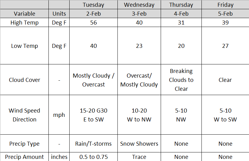
Tuesday

High temperatures should be in the mid 40s. Lows tonight will be in the low 30s. Winds should be light and variable with increasing clouds through the overnight.

Wednesday

Temperatures should be in the low 30s throughout the day. Overcast conditions with heavy snowfall in the late afternoon. Accumulations Wednesday look to be in the 1-2" range. It will be very windy with gusts up to 40 miles per hour at times.

Thursday

The snow continues with snow accumulating up to 3 inches by late Thursday night. High temperatures should be in the low 30s. Lows should be in the low 20s by Friday morning.

Friday

Temperatures should bounce back into the low to mid 30s by Friday afternoon. A chance for scattered snow showers is possible at times during the day on Friday. Low temperatures should be in the low 20s. 

Saturday

Temperatures should be in the low 40s by Saturday afternoon. Sunny skies are expected. Temperatures should cool to the low 30s for lows.

Thursday, February 18, 2016

Spring-Like Temperatures on the Way

End of the week forecast 02/18/16 through 02/22/16


Summary

Warmer temperatures accompanied with stronger winds are expected to make their way into central Indiana through the end of the week and into the weekend. High temperatures should reach the upper 50s to lower 60s by Saturday. A chance for rain showers moves in late Saturday night and into Sunday. Saturday looks to be the best day to get out of the house and do something. 

Thursday

Temperatures should top out into the low to mid 40s for highs. Winds should be between 10-15 mph from the south-southeast. Thursday and Thursday night should remain dry.

Friday

Stronger winds should drive the temperatures into the upper 50s and maybe low 60s by late afternoon on Friday. Skies should be partly cloudy to sunny at times. No precipitation is expected.

Saturday

Temperatures should top out in the low 60s with gusty winds. Rain showers may move in late Saturday night with very minimal accumulations. 

Sunday

High temperatures on Sunday will be in the low to mid 50s with increased cloud cover. The majority of the rain looks to stay south of Kokomo for Sunday. However, light rain showers cannot be ruled out.

Monday

A passing cold front will cause temperatures to drop into the low 40s for highs on Monday. Northern Indiana may see a few snow showers throughout the day on Monday. Low temperatures will be in the upper 20s.

Wednesday, February 10, 2016

More Cold and Snow in the Forecast


02/12/2016 - 02/15/2016 Forecast


Friday

We could still be dealing with cold wind chills. Increased clouds throughout the day on Friday could bring chances for snow during the night. Accumulations look to be light and less than 1". High temperatures will remain in the low 20s. Low temperatures look to be near 10.

Saturday

High temperatures Saturday should be in the low to mid teens. Very cold temperatures are expected Saturday night into Sunday morning. Temperatures could be around 5 Sunday morning.

Sunday


Sunday high temperatures should be near 20. Low temperatures Sunday night will be in the upper teens and we will have to deal with increased cloud cover. A chance for snow is possible into late Sunday night and into Monday. Models are trying to pick up on accumulation with this system. It is still way too early to tell what is going to happen.  Early estimates of snowfall look to be between the 1-3" range. There could still be changes to this forecast. I will have further updates Saturday and Sunday.

Monday


Snow looks to continue into Monday. Conditions do look favorable for some snow accumulation, but it is way too early to slap any numbers on the storm. Temperatures should reach near the freezing mark on Monday afternoon. Low temperatures should be in the low 20s.

Monday, February 8, 2016

The Cold and Snow Returns

Work Week Forecast 02/08/16 through 02/12/2016
Highlight:

Cold temperatures and snow returns to central Indiana. Roads are expected to become slick for Monday evening and Tuesday commutes.


Monday

Skies will remain overcast throughout the day and into the overnight on Monday night. As of 2:30 pm, it appears that the snow will remain very scattered in nature. Around 1:00 pm, heavy sleet/snow was reported in downtown Kokomo. The radar image below shows snow in the Lafayette area headed toward Kokomo. 


As of now, snow accumulations will be between 0.5 and 1.00 inch Monday into Tuesday morning. Temperatures will drop into the low 20s. Scattered snow will continue through the overnight. Roads will become slick Monday afternoon and into Tuesday morning. 


Tuesday

Snow chances will continue and will remain scattered. Accumulations are expected to be less than an inch. Tuesday morning roads will be slick. High temperatures will be in the mid to upper 20s. Temperatures will tank Tuesday night with lows near 10. Scattered snow showers look to continue throughout the day on Tuesday with lake effect snow possible Tuesday night.

Wednesday

Snow showers are still possible on Wednesday. Temperatures Wednesday afternoon will only reach the mid teens. Lows Wednesday night will be between 5 and 10.

Thursday

I still think we could see a few snow showers sticking around early Thursday morning. Temperatures will be in the low 20s for a high. Low temperatures look to be similar to Wednesday night.

Friday

Friday looks to be similar to Thursday. High temperatures will be in the low 20s. Low temperatures Friday night into Saturday morning will be in the single digits once again.

Friday, February 5, 2016

Weekend Forecast and A Look Into Next Week

Weekend and Beginning of the Workweek Forecast 02/05/2016 through 02/09/2016


Friday

High temperatures on Friday should be in the mid to upper 30s by late afternoon. Clear skies will give way to partly cloudy skies this afternoon. Increased cloudiness is expected into the overnight. Because of this, I do not expect temperatures to be as low as they were this morning. Low temperatures Saturday morning should be in the mid 20s. Winds will remain calm throughout the day and overnight.

Saturday

Temperatures look to top out in the low 40s on Saturday. Partly to mostly cloudy skies look to dominate the day. Winds should remain light out of the southwest. Lows Saturday night should be in the upper 20s. 

Sunday

Superbowl Sunday looks to be warmer with high temperatures in the mid 40s. Rain and snow showers will move in late Sunday afternoon into Sunday night. Low temperatures will be in the upper 20s. 

Monday

Clouds will stick around all day on Monday with rain showers changing over to snow in the afternoon/evening hours. High temperatures will be in the mid 30s. Right now, it is still too early to decide on any accumulation. However, this clipper system does look like it has the potential to drop light accumulations throughout the region. Temperatures will drop into the low 20s Monday night into Tuesday morning.

Tuesday

Snow will continue into Tuesday morning/afternoon. Snow flurries may continue throughout the day with a decent north to northwest wind. High temperature will be in the upper 20s. Low temperatures look bone-chilling in the low teens Tuesday night into Wednesday morning.

Thursday, February 4, 2016

End of the Week and Weekend Forecast 02/04/2016 - 02/08/2016

Weather Forecast 02/04/2016 through 02/08/2016


Thursday

Clouds look to break by Thursday afternoon. High temperatures look to reach the low 30s with no precipitation. The wind will calm to less than 10 mph. Lows will be in the low 20s with mostly clear skies. 

Friday

High temperatures Friday should be in the upper 30s. Skies look to remain clear with a calm west to southwest wind from 5 to 10 mph. A few clouds may sneak in late Friday night into early Saturday morning.

Saturday

Slightly warmer air will filter into the area with high temperatures in the low 40s. Skies look to remain partly cloudy throughout the day. No precipitation is expected Saturday. Low temperatures Saturday night into Sunday morning will be in the upper 20s.

Sunday

Sunday looks to be mostly cloudy throughout the day with a chance of rain and snow later Sunday night. High temperatures will be in the low 40s. Low temperatures Sunday night should be around 30.

Monday

Models are showing potential snowfall from a clipper system Monday and Monday night. It is still way too early to forecast amounts as a lot can change between now and then. I will keep an eye on the system and provide more information regarding this chance of snow further into the weekend. High temperatures should be in the mid 30s. Low temperatures in the low 20s. The below image is the GFS model Hour 108, which is Monday afternoon at 1:00 PM. Model information can be obtained from http://weather.cod.edu/forecast/.


Wednesday, February 3, 2016

Weather Forecast 02/03/2016 through 02/07/2016

Weather Forecast 02/03/2016 through 02/07/2016


Wednesday

Temperatures will continue to fall on the back side of the cold front. By Wednesday night, temperatures look to drop to the low to mid 20s. Clouds will move into the area by the afternoon. A chance for snow showers is possible on the back side of the low pressure system during the day on Wednesday. The image below is the High Resolution Rapid Refresh Model of the possible rain/snow showers today. This image in particular is 3:00 pm this afternoon. Winds will range from 10 to 20 mph from the west and south west. No snow accumulation is expected.


Thursday

Clouds look to break by Thursday afternoon. High temperatures look to reach the low 30s with no precipitation. The wind will calm to less than 10 mph. Lows will be in the low 20s. 

Friday

High temperatures Friday should be in the upper 30s to low 40s. Skies look to be mainly clear with a calm west to southwest wind.

Tuesday, February 2, 2016

Work Week Forecast: Update and Tuesday Storm Information

Work Week Forecast 02/02/2016 through 02/05/2016


Tuesday

Clouds will hang around all day with approaching rain and thunderstorms Tuesday afternoon. Storms may be severe at times with gusty winds. Heaviest thunderstorms will be south of I-70. Sustained winds will be from 15 to 20 mph. Temperatures look to reach the mid to upper 50s by late afternoon. Temperatures will decrease beginning late night as the cold front passes. Low temperatures should be around 40. Temperatures will drop through the overnight. Rainfall accumulations look to be between a half an inch to three quarters of an inch. A few locations may receive heavier amounts. This primarily depends on the storm tracks.

Timing of Today's Weather

A few spotty showers are possible late morning into the lunch hour. Heavier rainfall will move in after noon. The main event for today looks to arrive late afternoon into early evening hours today. Timing for the start of the main line of storms looks to be between 5 and 7:00 pm tonight. Storms and rain should exit the area by midnight. Below is a forecast radar reflectivity image for 7:00 pm tonight. This image was obtained from the Earth System Research Laboratory High Resolution Rapid Refresh model.

http://rapidrefresh.noaa.gov/HRRR/Welcome.cgi?dsKey=hrrr_ncep_jet&domain=t7&run_time=02+Feb+2016+-+11Z

Wednesday

Temperatures will continue to fall on the back side of the cold front. By Wednesday night, temperatures look to drop to the low to mid 20s. A chance for snow showers is possible on the back side of the low pressure system during the day on Wednesday. Winds will range from 10 to 20 mph from the west and north west. No snow accumulation is expected.

Thursday

Clouds look to break by Thursday afternoon. High temperatures look to reach the low 30s with no precipitation. The wind will calm to less than 10 mph. Lows will be in the low 20s. 

Friday

High temperatures Friday should be in the upper 30s to low 40s. Skies look to be mainly clear with a calm west to southwest wind. 

Monday, February 1, 2016

Work Week Forecast 02/01/2016 through 02/05/2016

Work Week Forecast 02/01/2016 through 02/05/2016


Monday

Skies will clear this afternoon and the fog will burn off. Clear skies are approaching from the west. Temperatures look to increase into the low to mid 40s by late night. Winds will range from 5 to 10 mph. Clouds will filter back into the region overnight as the approaching cold front will bring a chance of rain and thunderstorms on Tuesday. Low temperatures Monday night will be in the low to mid 30s. 

Tuesday

Clouds will hang around all day with approaching rain and thunderstorms Tuesday afternoon. Storms may be severe at times. As of now, the Storm Prediction Center has central Indiana under a Marginal Risk for severe weather on Tuesday. The picture below was obtained from the Storm Prediction Center's website (link provided below the picture). Heaviest thunderstorms will be south of I-70.

http://www.spc.noaa.gov/products/outlook/day2otlk.html

Winds will be gusty at times with a sustained wind from 15 to 20 mph. Temperatures look to reach the upper 50s by late afternoon. Temperatures will decrease beginning late night as the cold front passes. Low temperatures should be around 40. Temperatures will continually drop through the overnight. Rainfall accumulations look to be between a half an inch to three quarters of an inch.

Wednesday

Temperatures will continue to fall on the back side of the cold front. By Wednesday night, temperatures look to drop to the low to mid 20s. A chance for snow showers is possible on the back side of the low pressure system during the day on Wednesday. Winds will range from 10 to 20 mph from the west and north west. No snow accumulation is expected.

Thursday

Clouds look to break by Thursday afternoon. High temperatures look to reach the low 30s with no precipitation. The wind will calm to less than 10 mph. Lows will be in the low 20s. 

Friday

High temperatures Friday should be in the upper 30s to low 40s. Skies look to be mainly clear with a calm west to southwest wind.