Work Week Forecast 02/02/2016 through 02/05/2016
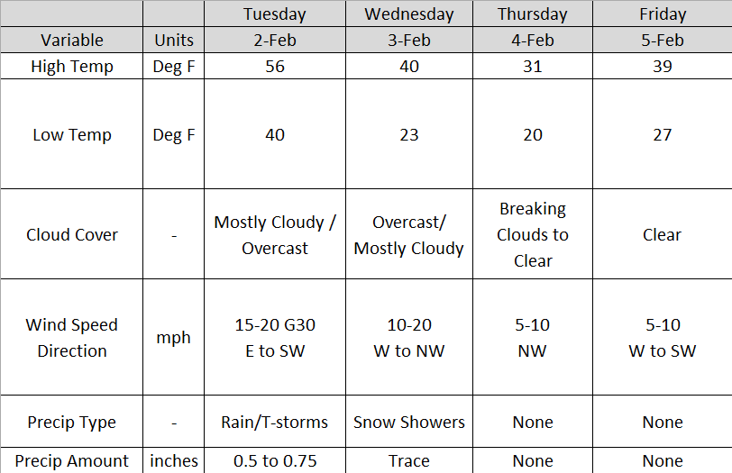
Tuesday
Clouds will hang around all day with approaching rain and thunderstorms Tuesday afternoon. Storms may be severe at times with gusty winds. Heaviest thunderstorms will be south of I-70. Sustained winds will be from 15 to 20 mph. Temperatures look to reach the mid to upper 50s by late afternoon. Temperatures will decrease beginning late night as the cold front passes. Low temperatures should be around 40. Temperatures will drop through the overnight. Rainfall accumulations look to be between a half an inch to three quarters of an inch. A few locations may receive heavier amounts. This primarily depends on the storm tracks.
A few spotty showers are possible late morning into the lunch hour. Heavier rainfall will move in after noon. The main event for today looks to arrive late afternoon into early evening hours today. Timing for the start of the main line of storms looks to be between 5 and 7:00 pm tonight. Storms and rain should exit the area by midnight. Below is a forecast radar reflectivity image for 7:00 pm tonight. This image was obtained from the Earth System Research Laboratory High Resolution Rapid Refresh model.

http://rapidrefresh.noaa.gov/HRRR/Welcome.cgi?dsKey=hrrr_ncep_jet&domain=t7&run_time=02+Feb+2016+-+11Z
Wednesday
Temperatures will continue to fall on the back side of the cold front. By Wednesday night, temperatures look to drop to the low to mid 20s. A chance for snow showers is possible on the back side of the low pressure system during the day on Wednesday. Winds will range from 10 to 20 mph from the west and north west. No snow accumulation is expected.
Thursday
Clouds look to break by Thursday afternoon. High temperatures look to reach the low 30s with no precipitation. The wind will calm to less than 10 mph. Lows will be in the low 20s.
Friday
High temperatures Friday should be in the upper 30s to low 40s. Skies look to be mainly clear with a calm west to southwest wind.
No comments:
Post a Comment